

 RTI Act
- You are here:
-
Home

-
Publications
- Research Updates
Research Updates
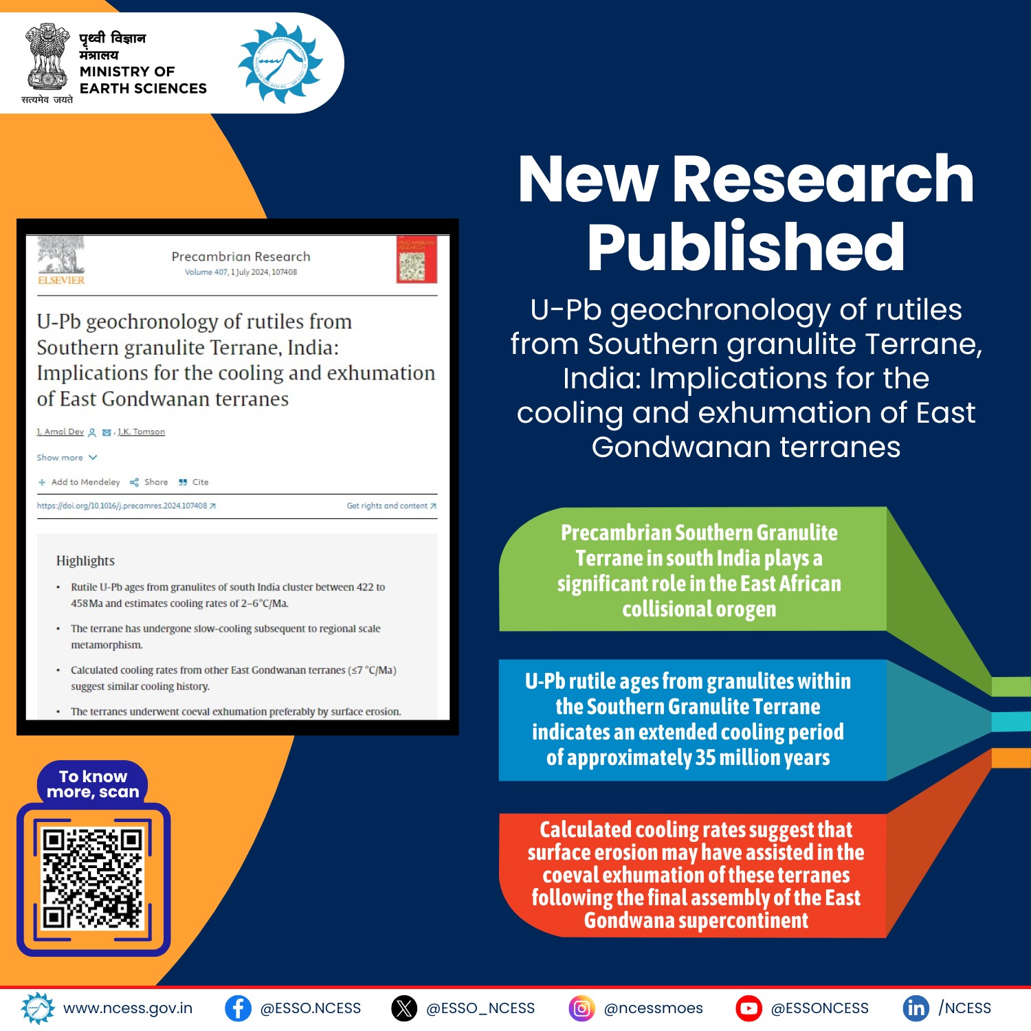
A new research by National Centre for Earth Science Studies Kerala unveils the cooling history of the Southern Granulite Terrane in south India. New U-Pb rutile ages suggest a 35-million-year cooling period postdating regional metamorphism.
Bibliographic Info: J. Amal Dev, J.K. Tomson. (2024).
https://doi.org/10.1016/j.precamres.2024.107408.
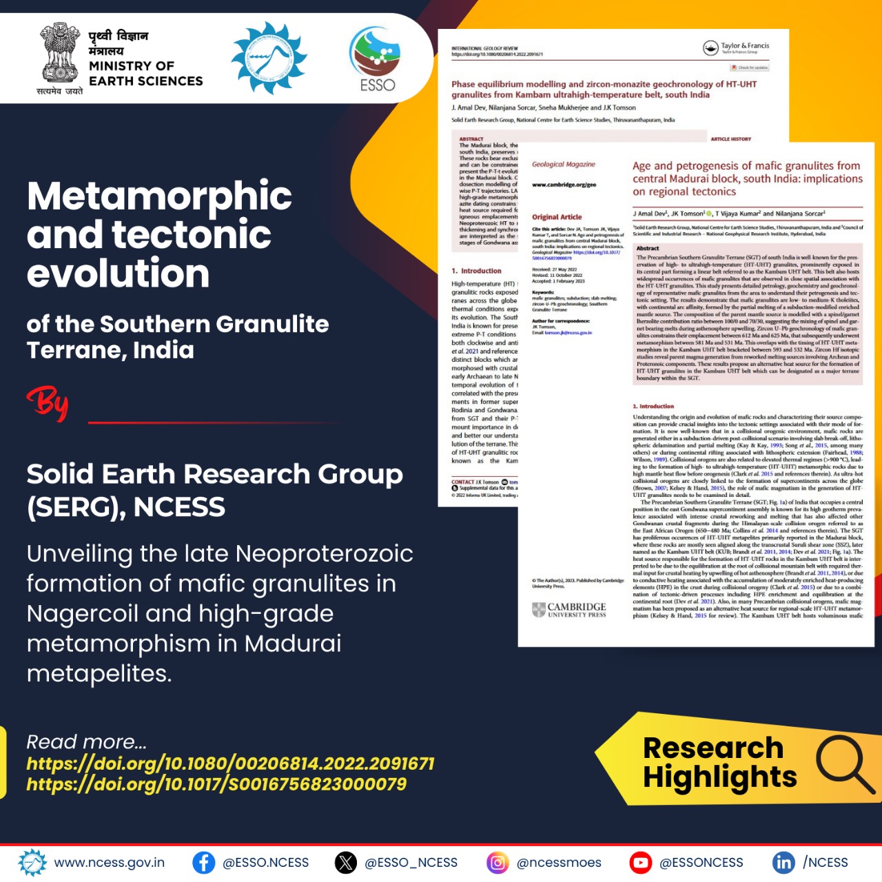
Detailed petrology, geochemistry, phase equilibrium modelling and geochronology of metapelites and mafic granulites from Madurai and Nagercoil blocks of South India were carried out to understand their petrogenesis and tectonic setting. The results demonstrate that mafic granulites from Nagercoil block had formed by the partial melting of a subduction- modified enriched mantle source that got emplaced during the late Neoproterozoic with magma generation from a reworked melting sources involving Proterozoic components. Metapelites from Madurai block record high to ultrahigh-temperature metamorphic conditions along a clockwise Paleoproterozoic record and a late Neoproterozoic high-grade metamorphic record. The results from these litho-units are interpreted as the signatures of collisional orogeny prevalent in the region during the final stages of the Gondwana assembly.
Bibliographic Info: Amal Dev, J., Tomson, J. K., Vijaya Kumar, T., Nilanjana Sorcar (2023). Age and petrogenesis of mafic granulites from central Madurai block, south India: implications on regional tectonics. Geological Magazine, Vol. 160 (5), pp. 955-971. https://doi.org/10.1017/S0016756823000079.
Amal Dev, J., Nilanjana Sorcar., Sneha Mukherjee., Tomson, J. K. (2022). Phase equilibrium modelling and zircon-monazite geochronology of HT-UHT granulites from Kambam ultrahigh-temperature belt, south India. International Geology Review, 1-19
https://doi.org/10.1080/00206814.2022.2091671.
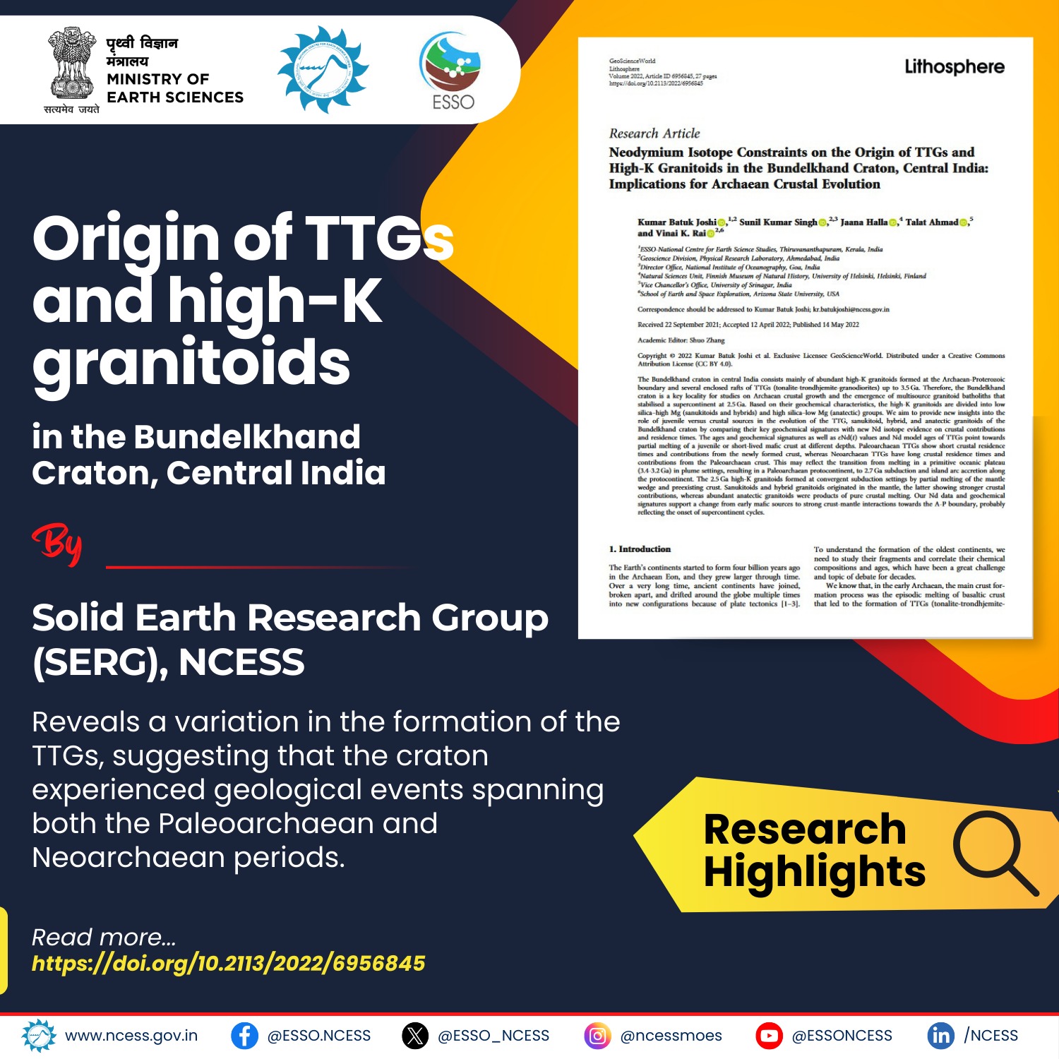
Combined geochronology, geochemical signatures, and Nd isotopic compositions allow us to draw the following conclusions on the evolution of the Archaean granitoids of the Bundelkhand craton: (1) The TTGs of the craton had formed as a result of partial melting of juvenile mafic crust at different depths with contributions from newly formed felsic crust in the Paleoarchaean and older felsic crust in the Neoarchean; (2) The 2.5 Ga high-K granitoids of the craton had formed at convergent subduction settings by partial melting of the mantle wedge and pre-existing crust. Sanukitoids and hybrid granitoids originated in the mantle, the latter showing stronger crustal contributions, whereas abundant anatectic granitoids were the results of the melting of the continental crust.
Bibliographic Info: Kumar Batuk Joshi, Singh, S. K., Halla, J., Ahmad, T., Rai, V. K. (2022). Neodymium isotope constraints on the origin of TTGs and high-K granitoids in the Bundelkhand Craton, Central India Implications for Archaean crustal evolution. Lithosphere, Vol. 2022 (Special 8), Art. 6956845. https://doi.org/10.2113/2022/6956845.
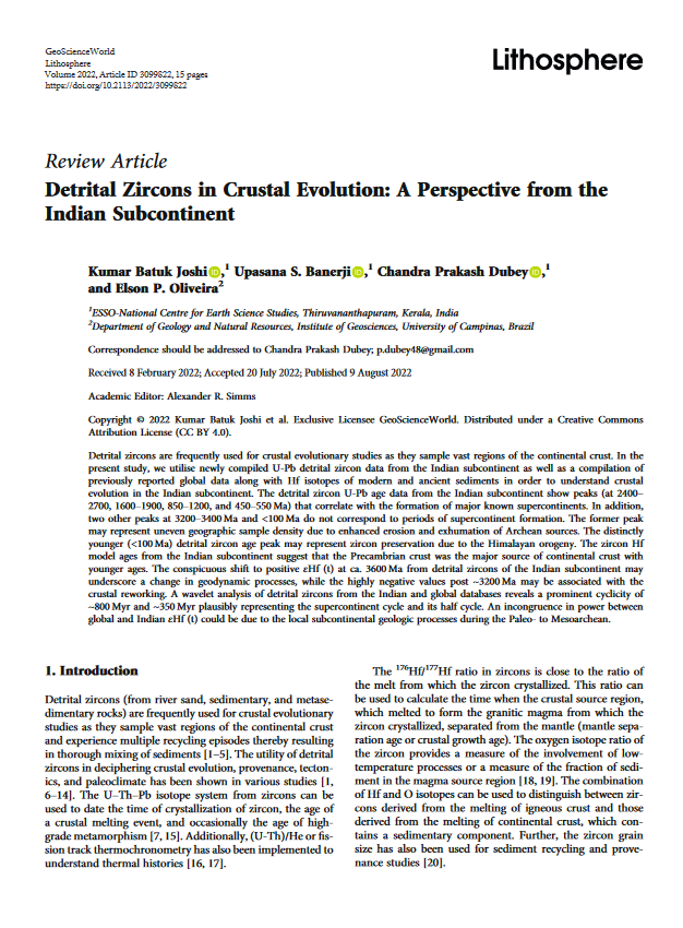
A compilation of available detrital zircon age data and their Hf isotopic compositions from the Indian subcontinent revealed the following about the crustal evolution in India. (1) The four significant/major peaks in the age spectrum at 2700-2400, 1900-1600, 1200-850, and 550- 450 Ma can be correlated with the major supercontinent cycles. (2) The peaks at <100 Ma and 3400-3200 Ma likely represent Himalayan orogeny and enhanced erosion and exhumation of Archean sources, respectively. (3) The zircon εHf(t) variations suggest that the Precambrian crust was the major source of young continental crusts. The positive zircon εHf(t) values from ca. 3600 to 3200 Ma age groups suggest a greater degree of mantle melting or a shift from stagnant lid to mobile/ intermittent lid tectonic environment. The highly negative zircon εHf (t) values after 3200 Ma signify a greater degree of recycling and reworking of the older continental crust probably implying the onset of plate tectonic processes; (4) The CWT wavelet analysis on detrital zircons from the Indian and global databases reveals a prominent cyclicity of ~800 Myr and ~350 Myr plausibly representing the supercontinent cycle and its half cycle. However, an incongruence in power between the global and Indian εHf(t) could be due to the local subcontinental geologic processes during the Paleo to Mesoarchean
Bibliographic Info: Kumar Batuk Joshi., Upasana S. Banerji., Dubey, C. P., Oliveira, E. P. (2022). Detrital Zircons in Crustal Evolution A Perspective from the Indian Subcontinent. Lithosphere, 2022(Special8),d3099822. https://doi.org/10.2113/2022/3099822.
The Kaladgi Basin is one of the several Proterozoic sedimentary basins of India. This basin has a binary evolutionary history with an angular unconformity separating the older deformed and younger undeformed rock sequences of the Kaladgi Supergroup, named the Bagalkot and Badami Groups, respectively. The Bagalkot Group is believed to be of late Paleoproterozoic to Mesoproterozoic in age. However, the timings of deposition of the Badami Group and the closure of the basin have remained speculative. Our 206Pb-207Pb dating of the youngest unit of the Supergroup, the Konkankoppa Limestone yielded a depositional age of 604 ± 25 Ma (MSWD=1.2). This age, considered together with the lowest 87Sr/86Sr ratio of 0.70781 observed in the formation, extends the active sedimentation of the Badami Group well into the Ediacaran Period. These data confirm the existence of a long duration depositional hiatus, of >500 million years, between the Bagalkot and the Badami Groups. Results of this study also refutes the claim that the sedimentation in most of the Proterozoic basins of peninsular India ended by 1000 Ma.
Bibliographic Info: Bivin G. George, Jyotiranjan S. Ray, Pillai, S. P., Mahala, M. K., Kumar, S., Kale, V. S. (2023). C-Sr-Pb isotope systematics of the carbonate sequences of Kaladgi Supergroup, India: Implications for basin evolution and correlation with Proterozoic global events. Precambrian Research, Vol. 388, Art. 107014.
https://doi.org/10.1016/j.precamres.2023.107014.
News and Events
Research Updates
- Tracing the Late Quaternary coastal evolution of Central Kerala, India
- Imaging of moho topography with conditional generative adversarial network from observed gravity anomalies
- U-Pb geochronology of rutiles from Southern granulite Terrane, India
- Metamorphic and tectonic evolution of the Southern Granulite Terrane, India
- Origin of TTGs and high-K granitoids in the Bundelkhand Craton, Central India
- Detrital zircons in crustal evolution: A perspective from the Indian subcontinent
- Age of Kaladgi Supergroup, India
