Uncategorised

Antimicrobial Photodynamic Therapy
The presence of bacterial biofilm on the tooth or root surface is a major cause of gingivitis and periodontitis. Mechanical removal of biofilm, adjunctive use of antibiotics and surgery are conventional methods of periodontitis therapy. In the light of recent reports about bacterial strains becoming resistant to frequent doses of antibiotics researchers are currently investigating the use of antimicrobial photodynamic therapy (aPDT) as an alternative to antibiotic drugs in the treatment of periodontal infections. During aPDT, intense light irradiation of affected lesion after application of photosensitizing dyes induces phototoxic reactions, which release oxygen free radicals that selectively destroy the bacterial cells.
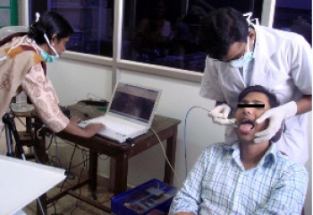
As part of this Indo-Bulgarian collaborative project it is proposed to develop technologies and treatment modalities for photo-inactivation of periodonto-pathogenic bacteria. The study involves identification of pathogenic bacteria (aerobic and anaerobic) present in periodontal pockets of local population, their culture and photo-inactivation in the presence of suitable non-toxic photosensitizers both under in vitro and in vivo conditions (Fig. 1).
A clinical trial has been initiated at the Govt Dental College to test the potential of using diffuse reflectance imaging detect and monitor periodontal infection by comparison with pocket depth and gingival inflamation. In patients diagnosed with aggressive periodontitis, PDT is performed (Fig. 2) with methylene blue as sensitizer at 10mg/mL and a laser (655nm) irradiation dose of 60 mW/cm2.
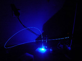
Fig. 1. Antimicrobial PDT of E. Fecalis bacteria in vitro in the presence of riboflavin
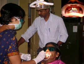
Fig. 2. Clinical trial for treatment of aggressive periodontitis using aPDT. The inset a close-up of the gingiva after application of the methylene blue.

Laser-induced Multispectral Fluorescence Imaging of Corals
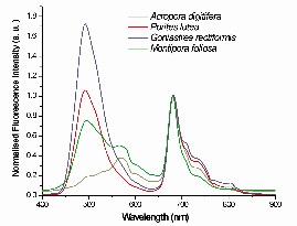
Fig. 1. LIF spectra of different species recorded in situ from corals in Palk Bay normalized to chlorophyll fluorescence peak intensity at 680 nm
Coral reefs are one of the most productive ecosystems on Earth. They are also the most sensitive among ecosystems to long term climate change. Around the world corals are under threat from a multitude of sources. Depending on their location, reefs have been damaged directly through harmful practices such as coral mining, overfishing, pollution, haphazard coastal development and even by careless pleasure diving by tourists. Lakshadweep archipelago, which consists of 12 atolls and 3 reefs, is also threatened by the change in environmental condition due to alterations in salinity, rise in seawater temperature, rise in carbon dioxide content of the seawater, pollution, overfishing etc. Understanding the impact of environmental changes on coral reefs by fluorescence imaging enables us to obtain knowledge on coral growth and their adaptation under ambient conditions, without disturbing their natural habitat.
In situ LIF measurements of corals such as Porites lutea, Acropora digitifera, Montipora foliosa and Goniastrea rectiformis were carried out using the LIFRS system from a boat in the Palk Bay near Rameswaram. The LIF spectra of corals was found to consist of peaks at 485, 550, 575, 685 and 730 nm that varies in intensity and position among coral species (Fig. 1). Change in fluorescence emission intensity and peak position with stress points to the role of host pigments in coping with stress. Our study has shown that coral species could be identified and stress induced bleaching and mortality could be detected based on fluorescence spectral signatures.
Laser-induced multi-spectral fluorescence imaging system (LIMFIS) was developed to record fluorescence images of corals (Fig. 2). Diode-pumped solid-state (DPSS) laser (457 nm) operated in the pulsed mode at 20 kHz is used as the excitation source. The expanded laser beam illuminates corals on the ocean floor and an intensified CCD camera records the fluorescence images through a liquid crystal tunable filter (LCTF) and camera lens. The LCTF is tuned to the coral emission peaks sequentially to record the fluorescence images and coral health-sensitive information can be obtained from the image intensity ratios (Fig. 3).
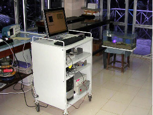
Fig. 2. Laser-induced Multi-spectral fluorescence Imaging System (LIMFIS) developed for remote sensing of corals
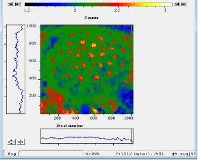
Fig. 2. Laser-induced Multi-spectral fluorescence Imaging System (LIMFIS) developed for remote sensing of corals

Atmospheric & Environmental Lab (AEL)
Greenhouse gases in coastal ocean, estuaries and other wetlands
Greenhouse gases affect climate on Earth through radiative forcing and modification of its energy balance. Carbon dioxide, methane and nitrous oxide are major greenhouse gases, in terms of their relative contribution to global warming. Wetlands and coastal regions play major roles in the global budget of methane and nitrous oxide, and coastal oceans are known to hold disproportionately large share of oceanic methane and nitrous oxide.
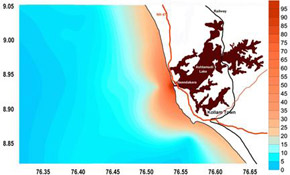
Distribution of dissolved Methane (nmol/l) in the coastal ocean (surface) off Neendakara during pre-monsoon season
Studies on the water to air fluxes of these gases as well as their dynamics in the coastal environment are being carried out. Natural and constructed wetlands, fresh water lakes and estuaries, forest swamps, coastal ocean, the role of aquatic vegetation on the transport of these gases from the wetland sediments to the atmosphere, etc., are covered under these studies. Estuaries and other wetlands in Kerala are under pressure from high population density and activities like coconut husk retting, tourism, etc., which influence the greenhouse gas production and emissions. The estuarine discharges to coastal ocean have been identified as a significant source of oceanic methane and nitrous oxide in the coastal regions.
These studies have shed light on the sources of these emissions as well as their temporal and spatial variations in this region. Water-to-air gas emission samples, water samples, and sediment samples are collected and brought to the laboratory for analysis. Methane is measured using FID and nitrous oxide using ECD on a gas chromatograph. Estuarine discharges are modeled using standard methodologies like LOICZ model.
Greenhouse gases in urban areas
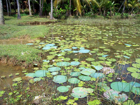
Aquatic plants enhance methane transport from the wetland sediments to atmosphere.
The concentration of industries, automobiles, household emissions, municipal waste and sewage accumulation and processing, etc., make urban regions hotspots of greenhouse gas emissions. Carbon dioxide, methane, nitrous oxide, carbon monoxide, and a variety of industrial gases including halo-carbons, sulphur compounds, etc., fall under this category. The ground level concentration as well as vertical profile of methane in the urban centres in Kerala is being studied. Large number of grab samples are collected and analysed through gas chromatography to determine the GHG concentration in them. Spatial distribution within the urban area is derived from these. These studies show that these urban centres act as net greenhouse gas emitters.
Urban Heat Islands
Urbanization leads to micro-climate changes, particularly with regard to the thermal structure of the location. Urban Heat Island (UHI) the elevated air temperature observed within the urban centre compared to its rural surroundings, is the most significant among such changes. Factors leading to this elevation of temperature in towns are changes in the thermal characteristics of the surface, modification of the air flow patterns, reduction in evaporative cooling and heat added by human activities
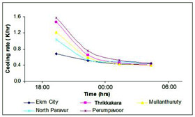
Cooling rates observed at a few locations in Ernakulam region. Differeces in the night time cooling rates at urban and rural environments is the cause for Urban Heat Islands.
UHI can affect the residents through heat stress and associated health disorders, increased energy consumption for space cooling and refrigeration, etc. It is estimated that a 1oC elevation in air temperature in warm climates can increase the peak electricity demand by as much as 5%. Heat stress can precipitate cardiac problems in susceptible people. Studies on UHI are being carried out. Meteorological and physical parameters associated with the development of UHI are measured using equipment like sensitive air temperature and humidity recorders, infra-red thermometer, albedometer, soil moisture recorders, etc. These studies indicate the presence of moderate UHI of 1.4 to 3.8 oC in our cities, depending on the season, location, etc.

Sunlight-induced Fluorescence Imaging of Vegetation

Fig. 1. Sunlight-induced multi-spectral fluorescence imaging system for vegetation stress studies
Plant growth and development depend on photosynthetic efficiency, which in turn is related to the availability of sufficient water, mineral nutrients, carbon dioxide and light. Insufficient availability of these vital inputs due to natural or anthropogenic stress can affect the photosynthetic performance directly or indirectly, thereby altering the optical fluorescence properties. Photosynthesis is particularly sensitive to stresses, such as drought, nutrient deficiencies, acid rain, suspended particulates and air pollutants.
A multi-spectral imaging system was developed for fluorescence imaging of sunlight induced plant fluorescence from different types of vegetation (Fig. 1). The inverse dependence of plant fluorescence on photosynthetic activity is used to assess the impact of stress on plants. The small component of emitted fluorescence on absorption of solar energy is extracted from the reflectance spectra of plants by using the Fraunhofer discrimination technique. It is hoped that this instrument could aid in passive remote sensing of vegetation through the measurement of fluorescence at selected Fraunhofer lines located close to the fluorescence emission peaks, followed by digital processing of the recorded images. The study covers monitoring of vegetation health in different plant types exposed to varying climatic conditions.

Fig. 2. Variation in chlorophyll ratio of a senescent to dry leaf on dark background.
Vegetation fluorescence reflects the physiological status of plants and this principle has been applied in classification of plants, identification of vegetation characteristics, physiological and nutrient stress detection, weed infestation identification and related developments. It is well established that the intensity ratios of these emission bands, in particular the chlorophyll bands, are good indicators of photosynthetic function. In Fig. 3 the F685/F720 fluorescence intensity ratio image of a partially dry leaf is displayed in false colours with value of 0.66 for blue colour (green area of leaf) , 0.829 for green colour (senescent leaf) and 0.918 for red colour (dry leaf).
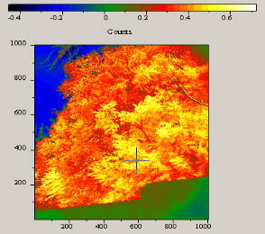
Fig. 3. False colored NDVI image of a tree 100 meter away from camera.
Reflectance images of distant trees were recorded at 720 and 687 nm with the imaging camera. From the visible and NIR light reflected by vegetation, the Normalized Difference Vegetation Index (NDVI) that describes plant productivity was computed using the relation NDVI= (NIR-VIS)/ (NIR+VIS). For the green denser region of vegetation, the NDVI ranges from 0.5 to 0.7. The false coloured NDVI image of a tree is shown in Fig. 3; the area with vegetation is shown as red to yellow in colour with the NDVI varying from 0.2 to 0.6. Healthy vegetation absorbs most of the visible light that falls on it and reflects a large portion of the NIR light. Unhealthy or sparse vegetation reflects more visible light and less NIR light, yielding a lower NDVI. The fluorescence ratio F687/F720 shows increasing trend with senescence from 1.22 to 1.35 while the NDVI from the corresponding image area shows a decreasing trend from 0.27 to 0.13.

Biophotonics Laboratory (BPL)
Biophotonics is an emerging sector of scientific convergence, integrating the application of optical sciences and technologies to life science and clinical medicine. An increasing number of scientific discoveries occur at the boundaries of traditional academic disciplines through interdisciplinary collaborations that advance the frontiers of science. Research conducted under the umbrella of biophotonics in CESS falls in the border zones of physics, biology and medicine.
 The interaction of light with matter is interesting as well as perplexing when we perceive closely. Light is essential for all forms of life within the biosphere and it is the ambient light that supports photosynthesis in plants and many photochemical and photobiological reactions in the human body. Application of optical spectroscopy techniques to life sciences research were initiated in 1992 through a research program funded by the Council of Scientific & Industrial Research (CSIR) to study nutrient and water stress in plants by the Laser-induced Fluorescence (LIF). The successful completion of this project led to initiation another program to study the impact of automobile pollution in medicinal and crop plants of Kerala funded by the STED, Govt of Kerala.
Sensing the vast potential of optical spectroscopy techniques in the healthcare sector, a major project was initiated to develop and test a portable “optical biopsy” device for non-invasive detection oral malignancy, in collaboration with Regional Cancer Centre (RCC), Trivandrum, with support from the Department of Science & Technology, Govt. of India.
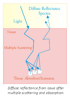
Oral cancer is a disease that affects millions of people across the globe and the number of patients is on the rise. India accounts for a third of the world burden of oral cancer. During transformation towards malignancy it is known that tissue composition, its morphology and vascularity gets altered. We noticed that in addition to changes in the laser-induced autofluorescence (LIAF) characteristics of tissues, the diffuse reflectance spectra gathered from spatially distant points from the incident beam showed effects of multiple scattering and absorption. We proposed that the intensity ratio of oxygenated hemoglobin absorption dips at 545 and 575 nm in the diffusely reflected tungsten halogen spectra of tissues could be used to detect early symptoms of tissue transformation towards malignancy.
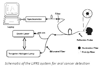 This led to the development of a Laser-induced fluorescence and reflectance spectroscopy (LIFRS) point monitoring system, which was tested through clinical trials to detect different stages of oral cancer, including premalignant stages, with the help of SRRS algorithms developed to categorize lesions. The LIFRS instrument built was also found useful for investigating plant stress, coral health, detection of dental caries and tooth demineralization. These studies have led to the development of multi-spectral imaging systems for studying corals, vegetation and cancer. At present the laboratory focuses on:
Collaborating Institutions:
- Insitute of Electronics, Bulgarian Academy of Sciences, Sofia, Bulgaria
- Regional Cancer Centre, Trivandrum
- Govt: Dental College, Trivandrm
- Rajiv Gandhi Centre for Biotechnology, Trivandrum
- Azzezia Dental College, Kollam
- M/s. Vinvish Technolgies Pvt Ltd, Technopark, Trivandrum
- M/s. Innobreeze Technologies, Trans Asia Corporate Park, Kakkanad, Kochi
Instruments Developed:
- LIFRS system for point monitroing of oral cavity cancer
- LIMFIS for laser-induced active remote sensing of corals
- Multi-spectral EMCCD camera system for fluorescence and reflectance imaging
Facilities Available:
- Nitrogen Laser (Spectra Physics, USA, model: VSL-337) with 30KW peak power, 4ns pulse width, 0.1 nm bandwidth, rep rate: up to 20 Hz, 120 µJ /pulse at 337 nm
- Nitrogen laser pumped Dye laser (Spectra Physics Model: DYE 110) with 360-950 nm tunable, 3 -10 nm bandwidth).
- DPSS 457 nm Deep Blue Laser, 200 mW (Shanghai Dream Lasers, PRC, Model: SDL-457-200T)
- Fiber Coupled Diode lasers with 1 W, CW power @ 635 nm and 655 nm (CNI Optoelectronics Tech, PRC)
- Miniature Fiber-optic Spectrometer (Ocean Optics USA, Model; USB2000FL) with Tungsten halogen source (Ocean Optics USA, Model; LS-1-LL), fiber-optic probes and fiber adapter kit and accessories.
- Intensified CCD Camera (Andor Technology, Ireland, Model: DH734-18-FO3)
- Liquid Crystal Tunable Filters (Cambridge Research Instrumentation , USA, Models:VIS-20-20 and VIS-7-20)
- Electron Multiplying CCD (EMCCD) camera (Andor Technology, Ireland, Model: LUCA-R-DL-604)
- Hand-held portable Photosynthesis System (CID Inc, USA, Model:CI-340)


 RTI Act

