

 RTI Act
Field Research Facility (FRF)
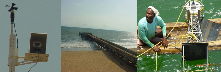
The Field Research Facility established at Valiathura, near Thiruvananthapuram is equipped with facilities for collection of coastal environmental data for various projects. The important facilities available are Valeport wave gauge, anemograph and automatic video camera. The pier jetting out into the sea for a length of roughly 100-m from the shoreline is a very useful platform for installation of equipments and for making littoral environmental observations. A wave rider buoy has also been installed in the shallow waters off Trivandrum under a project funded by the INCOIS, Hyderabad. The Datawell Directional Waverider buoy measures the wave height and period by measuring the vertical acceleration by means of an accelerometer placed on a gravity stabilized platform and by double integrating the acceleration to get the displacement. The direction of wave approach is measured based on the translational principle.The data from the buoy are transmitted through VHF/GSM/INSAT-1C satellite system to the shore station located at CESS Thiruvananthapuram at synoptic hours. The data transmission is at every three hour interval. Also, the data from GPS mounted on the wave rider buoy can be used to monitor the position of the buoy continuously and in tracking the buoy. The data received from the buoy would be then sent on real-time to INCOIS, Hyderabad for further dissemination to the operational users such as India Meterological Dept (IMD), Coast Guard (CG), INCOIS, Navy, ONGC and other agencies.
The data will be disseminated to the fishermen and coastal community by organising workshops and by employing methods of mass communication like television, radio, news paper, VHF, etc. The real time validation of sea state forecast for the Kerala coast will be carried out by INCOIS. Further, the dissemination of sea state conditions and potential fishing zone through electronic display board being established at Vizhinjam fishing harbour and other important fishing harbours.